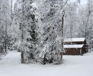
This one will probably melt off, like the first two. Expect we won't get the permanent snowpack for a awhile yet.
Update Sun. AM...Looks like about 4 inches of heavy, wet snow overnight. The forecast is for more next week, so maybe this is the beginning of the winter's snowpack.
Last year at this time I rode the Guzzi to the "air heads" meeting, well not this time!
Here's the NWS summary for September...
Unlike August, September 2019 returned to the summer's previous pattern of above normal temperatures and below normal precipitation. The warmest temperatures of the month occurred on the 2nd and 13th when the temperature reached 73° F. The coldest temperature was 27° on the 24th, while the 22nd was the first day below freezing. The average temperature for the month was 48.4°, which was 3.5° above normal
Rainfall totaled 1.04" for September, which was 0.06" below normal. The greatest daily rainfall was 0.35" on the 29th. Unlike many previous Septembers, there was no measurable snowfall this month.
Update 2. The Climate Center finally got around to posting their September summary.


Not looking forward to those views here.
ReplyDeleteWell it's different every fall. Last year we had the warmest Oct. on record and didn't get any snow until Halloween. Two years ago there was a big dump of snow in Sep. but it all melted in Oct. The weather up north, well you never really know!
ReplyDeleteIt's beautiful looking at those pics. I live on a tropical island and today it has been tremendous heat. Everything is so different but very beautiful ... Thank you for sharing ...hugs !! ...{My english it's not well...sorry for it but I love to share}....Vanessa
ReplyDeleteThanks. good to hear you like it. Sometimes my English is not too good, either!
ReplyDelete